Project Scope
Ingenia conducted a UAV Inspection as part of its project workflow to efficiently deliver design solutions and visual representations for the client’s project. The scope included the design of Access Platforms across three locations on the site. Two of these locations were suitable for traditional terrestrial point cloud scans, while the third, due to its height and complexity, required a more innovative approach.
Challenges
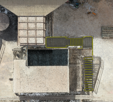
Cooling Tower 1, one of the three sites, posed a challenge for traditional point cloud capture due to its height and environmental conditions. Its difficult access necessitated an alternative method to gather precise measurements. Additionally, the proposed solution needed to comply with site standards and regulations.
Solution
Ingenia employed UAV Inspection technology combined with photogrammetry, merging UAV mission data with total station points to achieve a precision of +/-10mm or less. This approach eliminated the need for multiple site visits by capturing all required dimensions in a single pass.
After obtaining an accurate point cloud, the data was integrated into our 3D model to develop a tailored design for the Access Platform. The design not only addressed the platform’s specific location but also ensured full functionality, providing access to all required areas of the cooling tower. The platform was fabricated and successfully installed within a few weeks.
Our Services Discover how our engineering services can support your next project!
